MelAir Ride start from University Hill
Full Ride
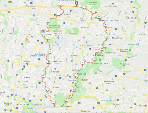
We start riding at University Hill along the M80 Ring Road Trail to Airport West, and go through Melbourne Airport industrial area to the Aircraft Viewing Area near the Control Towers for a brief rest and observation of the aircraft. We then ride through Tullamarine to a cafe rest stop. Continuing, we proceed through Westmeadows and Attwood to Broadmeadows and the Merlynston Creek Path back to the Ring Road and onto the finish at University Hill.
Shorter Ride
The option exists to not go all the way to the Control Tower Aircraft Viewing Area (approx. 8km saved). There are also short cuts through Westmeadows and Broadmeadows.
Full Length: 60 Km
Shorter Length: 53 Km
Difficulty: Challenging
Elevation: Hilly
Path Types: Shared User Path (Concrete/Asphalt)
Arterial Roads
On-Road(No Bike Lane) ≤ 80 km/h
On-Road(w/ Bike Lane) ≤ 80 km/h
Trails:
Ride Map


Leave A Comment